
CONTACT LOST WITH DRISHTI, WORLD’S FIRST OPTOSAR SATELLITE
CONTACT LOST WITH DRISHTI, WORLD’S FIRST OPTOSAR SATELLITE
Why in the News?
- Mission Setback: Bengaluru-based space start-up GalaxEye has lost communication with Mission Drishti, the world’s first OptoSAR Earth observation satellite, after an anomaly linked to a geomagnetic solar storm, marking a significant setback in India’s growing strategic partnerships in the global space sector.
- Significance: The incident highlights the challenges posed by space weather to satellite operations and the need for robust radiation-hardened spacecraft systems, particularly amid growing strategic competition in space technology between major powers including US and China.
MISSION DRISHTI
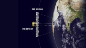
- Unique Innovation: Mission Drishti is the world’s first OptoSAR satellite, integrating Electro-Optical (EO) and Synthetic Aperture Radar (SAR) sensors on a single Earth observation platform, representing a breakthrough in satellite technology amid intensifying strategic competition in the space domain.
- Launch Details: The satellite was launched on 3 May 2026 aboard Falcon 9 from Vandenberg Space Force Base and is India’s largest privately developed Earth observation satellite, demonstrating the country’s strategic alignment with international space launch capabilities.
- Operational Advantage: Combining EO and SAR imaging enables continuous Earth observation under day-night conditions and through cloud cover, significantly improving surveillance and monitoring capabilities crucial for Indo-Pacific strategy implementation and regional security architecture.
- Mission Anomaly: During the Launch and Early Orbit Phase (LEOP), the spacecraft experienced an anomaly, with preliminary analysis indicating radiation effects from a geomagnetic solar storm affecting a critical onboard system.
- Current Status: Communication with the satellite became intermittent before being completely lost, and although recovery efforts continue through diplomatic engagement and multilateral engagement with international space agencies, the probability of restoring contact remains low.
OPTO-SAR TECHNOLOGY & IMPORTANCE
- Electro-Optical Imaging: EO sensors capture high-resolution images using visible and infrared light, making them suitable for mapping, agriculture, and environmental monitoring under clear weather conditions, supporting regional economic integration initiatives.
- Synthetic Aperture Radar: SAR sensors actively transmit microwave signals, allowing imaging regardless of cloud cover, rainfall, smoke, or darkness, making them ideal for all-weather surveillance critical to Indo-Pacific strategy and regional security cooperation frameworks.
- Combined Capability: Integrating EO and SAR provides comprehensive Earth observation by combining high-detail optical imagery with all-weather radar intelligence, enhancing accuracy and reliability for maintaining a rules-based international order through transparent monitoring.
- Strategic Applications: OptoSAR satellites support border surveillance, disaster management, maritime security, precision agriculture, infrastructure monitoring, and climate studies, playing a vital role in Indo-Pacific strategy implementation, QUAD partnership objectives, defense cooperation agreements, and the cooperative security framework while respecting ASEAN centrality in regional engagement strategy.
- Commercial Significance: Such satellites strengthen India’s growing private space ecosystem, enabling indigenous high-resolution geospatial intelligence for both civilian and strategic applications, fostering economic interdependence through technology exports and enhancing Indo-Pacific strategy through commercial space capabilities.
SPACE WEATHER (GEOMAGNETIC SOLAR STORMS)● Definition: Space weather refers to changing conditions in space caused by solar activity, including solar flares, coronal mass ejections (CMEs), and high-energy charged particles emitted by the Sun. ● Geomagnetic Storms: A geomagnetic storm occurs when charged solar particles interact with the Earth’s magnetosphere, disrupting magnetic fields and affecting space-based and ground-based technologies. ● Impact on Satellites: Increased radiation can damage electronic components, disrupt communication, degrade sensors, alter satellite orbits, and cause temporary or permanent mission failures. ● Other Effects: Severe space weather can interfere with GPS navigation, radio communications, aviation systems, and electricity transmission networks, particularly at high latitudes. ● UPSC Relevance: Important for GS Paper III – Science & Technology, Space Technology, Disaster Management, and Internal Security, as well as Prelims – Solar Physics, Magnetosphere, and Satellite Technology. |